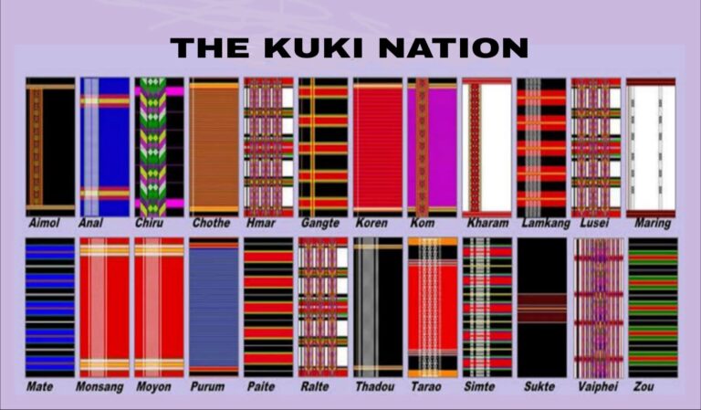
Introduction: The demand for a Kuki state or Union Territory under the Indian Constitution is often seen as a demand only for the Kuki community in Manipur. However, the so-called Kuki Country or Kukiland — spanning the Chittagong Hill Tracts in Bangladesh, parts of Northeast India, and western Myanmar — is a matter of historical record. Kukiland is not a dreamland or a new claim. It is a documented geographical and political reality that existed for centuries before British rule, before Manipur became a state in 1972, and before India became independent in 1947. The oldest proof comes from a Sanskrit copper plate of 1195 AD found in Sylhet, which records land bounded by Kukiland and is preserved in the Gazetteer of Bengal and North-East India.
Sanskrit Copper Plate of 1195 AD Records Kukiland
The oldest and most concrete proof of Kukiland comes from a Sanskrit copper plate grant of 1195 AD found in Sylhet. The grant records a land deed where the eastern boundary is marked as Longai and Kukiland and the western boundary as the Gopala River. This inscription is preserved and cited in the Gazetteer of Bengal and North-East India. It proves that a territory officially called Kukiland existed more than 800 years ago, long before modern states were formed.
This record is supported by the Rajmala, the royal chronicle of Tripura. During the reign of Dhanya Manikya (1490-1515), the Rajmala records a quarrel between the Tripura king and the Kukis over a white elephant. This shows that the Kukis were not a small jungle tribe but a powerful neighboring polity capable of challenging a kingdom and negotiating on equal terms.
Kukiland / Kuki Country: G.A. Grierson
The most authoritative colonial definition is by Sir George Abraham Grierson in the Linguistic Survey of India, Volume III, Part III, 1904. He wrote: “The territory inhabited by the Kuki tribes extends from the Naga Hills in the north down into the Sandoway District of Burma in the south; from the Myittha River in the east, almost to the Bay of Bengal in the west. It is almost entirely filled up by hills and mountain ridges, separated by deep valleys.”
Grierson clarified that this was an independent hill country, not part of any princely state. The hereditary chiefs were called Haosa. The settlement was described as an ‘independent hill country’ where central authority loosely controlled distant chiefs due to difficult communication, as per files in the National Archives of India. British maps of that era marked the Chittagong Hill Tracts as Kuki Country and the surrounding hills as Kuki Hills, covering nearly 50,000 square miles. This is the only name with cartographic legitimacy that still appears in the Presidential Order for Scheduled Tribes since 1956.
British Historical Record of the Kuki Independent Hill Country
When the British arrived, they consistently described the hill tracts as an independent Kuki Country. In 1777, Warren Hastings, the Governor General of Bengal, received a petition from the Chief of Chittagong seeking help against Kuki raids. In 1795, Major Michael Symes, in his book An Account of an Embassy to the Kingdom of Ava, recorded Captain Swinton’s 1763 expedition to a region bounded on all sides by the Cookie mountains. This proves that the hills around the Manipur valley were Kuki-inhabited and self-governed before Manipur’s official boundary was drawn in 1894-96.
British recognition continued for a century. In a Rajmala verse it is said, “The Kukis revolted but were subdued, and consented to pay their usual tribute of coins and ivory,” showing that they were independent enough to revolt and negotiate tribute, not mere subjects. In 1901, the British census documented Kuki settlements across Churachandpur, Pherzawl, and Chandel. Under the Treaty of 1834, the British handed over a significant chunk of this country to Burma to appease the King of Ava, which was later fragmented by international boundaries in 1947. All colonial maps marked it as Kuki Country.
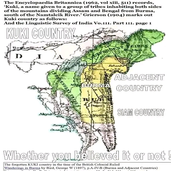
File Photo: Historical map from British colonial period marking “KUKI COUNTRY” — citing Encyclopaedia Britannica (1962) and Grierson’s Linguistic Survey of India (1904). Source: Wanderings in Burma by George W. Bird (1897).
The Tripura Rajmala and the Mahabharata: Royal Chronicles Recording Kuki Presence Since the 6th-7th Century
The Rajmala, the royal chronicle of 185 kings of Tripura, and the Mahabharata both link to early Kuki history. Scholars identify the Kukis with the ancient Kiratas described in the Mahabharata as forest warriors of the eastern hills. Tripura’s own legend traces its origin to King Tripur, linked to that Kirata lineage. The early chapters of Rajmala, dated by historians to 6th-7th century traditions, describe hill tribes paying tribute and rebelling, which later British historians identified as Kukis.
During the reign of Dhanya Manikya (1490-1515), the Rajmala clearly records a quarrel between the Tripura king and the Kukis over a white elephant. During the reign of Rajdhar Manikya after 1806, his successor faced continuous Kuki raids. Ramganga Manikya had to fight Kuki revolts, and Rajendra Manik had to severely punish the Kukis for their inroads. These entries show that the Kukis were a military power that could invade the Tripura valley, ally with the King of Udaipur, and demand tribute.
The Kuki Revolt in Tripura, 1860-1861
The Kuki Revolt of 1860-61 in Tripura, called by Col. E.B. Elly the ‘Great Kuki Invasion of the 1860s’, is recorded in Alexander Mackenzie’s History of the Relations of the Government with the Hill Tribes (1884). Maharaja Ishan Chandra Manikya appointed Balaram Hazari as Dewan to clear a debt of 11 lakhs in Chakla Roshanabad, imposing heavy taxes. His men raided the Dupamuha community for slaves. Thakur members of the Tripura royal family hiding among the Kukis instigated the attack. The Riang tribes, indebted to moneylenders, joined the Kukis.
On 31 January 1860, under Ratan Pooya alias Rutton Puiya, 400 to 500 Kukis swept down the River Feni and burst into the Chagalnaiya plains, burning 15 villages, killing 185 subjects, carrying off 100 captives, and looting gold and silver. In early 1861, they again attacked near Udaipur, killing 150 and taking 200 captive. British Political Agent W.F. Nuthall reported on 3 May 1871 that 450 Kukis from Kooding-mang attacked Toofai village, killing 28 people and burning 87 houses. Historians now describe this not as a mere raid but as a people’s rebellion against taxation and slavery.
The Anglo-Kuki War, 1917-1919
The full brunt of British colonial policy was felt in the Anglo-Kuki War of 1917-1919, one of the final attempts by the Kukis to end British rule. The cause was the British order to supply 2,000 Kuki men for the Labour Corps in France during World War I. The Kuki chiefs, protecting their independent status, refused.
British records state that they deployed 6,234 combatants from the Assam Military Police and Burma Military Police plus 7,650 carriers to cover 6,000 square miles of Kuki country. British casualties were 60 dead and 142 wounded. The British burned 126 Kuki villages, deserted 16, and confiscated 1,158 guns. Documents are preserved in the Manipur State Archives as the Kuki Rebellion Papers, 1917-1919. The war ended with the deportation of many chiefs to the Andaman Islands and the formal British designation of the area as Kuki Country in intelligence reports, proving that the British fought a nation, not just a tribe.
Kuki Participation in the Indian Freedom Movement
The Kukis joined the Indian National Army (INA) that fought alongside the Japanese in World War II to overthrow colonial rule. According to the Kuki National Front, the majority of INA pensioners in present-day Manipur are Kukis. This history shows that the Kukis fought in both World Wars — first against the British in 1917-19, and then with the INA against the British in the 1940s.
In 2012, the KNF published a book titled Kukiland (The Land of Kukis) during its silver jubilee at Ebenezer, Sadar Hills, detailing this contribution and the beginning of the armed movement by its founder Nehlun Kipgen in the late 1980s for a separate administrative unit called Kukiland within the Indian Union. Modern political demands have a clear paper trail: On 24 March 1960, the Kuki National Assembly submitted a memorandum to Prime Minister Jawaharlal Nehru demanding a separate Kuki state. In 1987-88, the Kuki National Front and the Kuki National Organisation were formed. The Kuki State Demand Committee now claims Sadar Hills, Churachandpur, Chandel, and parts of Tamenglong and Ukhrul — more than 60% of Manipur’s area — as part of Kukiland, demanding Union Territory status with a legislature under Article 3.
Conclusion: The story of Kuki Country, also known as Kukiland, is a historical record and a remembrance of an old country that was divided without consent. From the copper plate of 1195 calling it Kukiland, to Symes in 1795 calling it the Cookie mountains, to Grierson in 1904 mapping 50,000 square miles as Kuki-inhabited territory, to the Rajmala recording Kuki resistance since the 6th-7th century, to Mackenzie recording the Great Kuki Revolt of 1860-61 in Tripura, to the British burning 126 villages in 1917-19 to crush its independence, all documents point to one fact: an independent hill country existed and was governed by Kuki chiefs.
Today, organizations argue that the hills constitute 90% of Manipur’s geography but receive unequal development. Their demand for Kukiland within India under Article 3 is therefore not secession but restoration — a demand for security and a home where they can live as Kuki, by history, by blood, by land, and by politics.
By Suan Muanlian Zou
Compiled from historical documents, British archives, Rajmala & Grierson Survey.